
Baltistan covering an area of 26,000 square kilometer, comprises 5 vallys: Skardu, Khaplu, Shigar, Kharmang and Rondu. The Baltistan is the part of Northern Areas of Pakistan. These vallys are very important from the mountaineering, trekking and mountain related adventure activities. The northern territory of Baltistan contains four peak above 8000 meters, such as K-2 (8611-M) (Second highest mountain in the world), Gasherbrum-I (8068-m), Broad Peak (8048-m), and Gaserbrum-II (8035-m), and many other above 7000 meters peaks, such as Masherbrum, Gasherbrum-IV, Muztagh Towers, Latok, Baintha Brakk, Chogolisa, Baltoro Kangri, and many more.
Since time began, Baltistan has remained isolated from the rest of the world. It was first mentioned in the annals of an AD 747 Chinese military expedition to aid Ladakh against a threatened invasion from Tibet. Fascinated, the ancient Chinese geographers named it the “Tibet of the Apricots”, because of the abundance of this fruit that grew there, and still does. Long a Buddhist country, Islam was embraced in the fifteenth century and during the Mughal era it was annexed to India. But when Aurangzeb died it soon reverted to its isolated, independent ways, only to come under a succession of local rulers, Dogra, Sikhs and Afghans, finally coming into the Kingdom of Kashmir. At independence in 1947, Howeve, Baltistan chose to join Pakistan, and now the Baltistan is the Part of Pakistan.
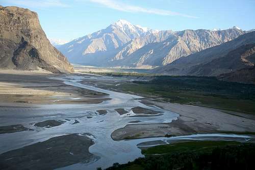
Within fifteen minutes of taking off from the Islamabad Airport, in PIA scheduled flight, we will be in a virgin world snaking through mountain passes and following emerald ribbons of rivers, the plane will be often lower than the level of the treacherous road. Every turn will brought a breathtaking new vista, and as we will leave habitation behind, we will enter a forest of peaks and nature of such staggering perfection that it flooded one simultaneously with a soaring joy and a stark realization of the absolute insignificance of man. Leaving the plain, the most immediate impression is that of disorientation. The valley and the rock and the desert plains have no likeness to any other landscape, as if the Sahara had been dropped down between massive walls of rock. There are no perspectives. So complete is the circle of mountains everything narrow and the eye is ever confused. Lying within this ring of 5000 meters high mountains that glimmer through the haze in varying shades of purple, grey, and ochre, the jade river Indus snakes sinuously between the ribboned, wind-blown sand dunes close beneath a 200 feet high island of massive rock. It’s here that Skardu straggles along the plateau.
From Islamabad most of the Climbing expedition teams, trekking parties and other visitors like to travel on Karakoram Highway. Not until 1978, with the completion of the 170 kilometers long Gilgit-Skardu Road, did Baltistan have any permanent access to the rest of the world, even in 1980s the citizens retained their self-sufficiency and independence, aloof from the twentieth century and its wonders. So formidable in the scale of its colour and texture, savagery and desolation is the Indus gorge out of Skardu that not even Balti’s ventured to cross it. The road to Skardu is one of the most dramatic roads in the world, following the narrow, dark, bleak, and stupendously high ravine of the Indus for mile after mile. Never a blade of gross relieves the monotony of the hostile rock. Only the jade green river, tumbling and foaming in stretches of white water, relieves the grey, brown, sere, and unrelenting walls of boulders- strewn rock, and cliffs. Like its larger sister, the Karakoram Highway, it represents one of the world’s major feats of civil engineering construction and already Skardu, long a Mecca for the high altitude mountaineers, have become a major tourist resort as the coaches, cars, and jeeps flood down the road across more than 20 bridges to the town.
No diminutive this, though Baltistan, crowned by the Majesty of K-2, at 8611 meters the world’s second highest mountain, sit an average high of 4500 meters. No relief map or guide book can lead you through this wilderness of lost horizons. There are none. The horizon merge in a tumultuous maze in which west and east, north and south, lurch giddily from one side of the eye to the other in utter confusion.
The Skardu is the capital city of Baltistan. Its real attraction is as gateway to the grandest sight in all nature, Concordia, the amphitheatre of the ten of the world’s thirty greatest mountains, the adjacent glaciers and peak, and its closeness to Lake Satpara, one of the hidden pearls of Baltistan.
At 2314 meters and due to confluence of the Indus and Shigar rivers, this is the capital town of the Baltistan. It has a pleasant climate has been the capital for a long time. In summer dusty winds frequently arise during the afternoon and continue till evening. Scattered among the apricots trees, poplars, willows and bushes are the residences, Government Offices, Banks, hospital, mosques, places, shops, markets and hotels. The shops and markets sales the food items, camping equipments, fur toques, Karakul fez, turbans and flowing togas of rough wool worn by the local inhabitants. Mountaineering and Trekking parties arrive here, stay for a short period and leave as quickly as possible for the mountains. The airport is situated 16 kilometer south-west of the Skardu. The most important monuments in the region is the rock carving of Buddha, some one and half kilometer south on the road to Satpara. It dates back to the 10th century AD. The entire surface of the rock, 8 meter high and some 5 meter wide, is carved with great imagination and skill. At 15th century aqueduct located in the town is an interesting feature to see. The fort of Kharpochu, which stands high up on the rock of Skardu, overlooks the streets of the town. Hotels for tourist are available, as there are many hotels. International/domestic telephone calls are available. The internet facilities are also available.
While waiting for a flight, bus, jeep or car, worthwhile diversions include. Going around the eastern end of the Skardu Rock, you come to village of Narsok, where a pure spring emerges from the base of a monolithic rock. The ascent of Skardu rock is quite tough. From Skardu fort there is an extended view over cultivated fields and the Indus River below. Lake Satpara is about 6 kilometers south-west of the Skardu.
KHAPLU
At 2355 meter, this historic town lies on the south side of the Shyok River, among innumerable trees on a fertile alluvial plain. The Khaplu is the District Headquarter of the Ganchee District. Facilities include a rest house, shops, and a few hotels and telephone. It is about 103 kilometers east of Skardu and can be reached by bus, van, jeep and car. The ever changing landscapes follow the sandy valley floor, black mountains reflecting in the waters of the Shyok River. On the slopes, little communities have carved their terraced fields and homes out of the mountainside, diverting the waters along a network of ancient irrigation aqueducts.
The capital of this valley, distinctively Tibetan in its people and architecture, is spread out along the greenest and broadest bowl of the valley, an arena that for the non-trekker is the key point to of the entire visit to Baltistan. For only in Khaplu, so high and close together are the regions other valleys, do you catch sight of “raison d’ etre” for any visit to Baltistan, its mountains. Here, in the early morning, as the sun slopes above the eastern horizon, its rays burst in a dazzling shower of diamonds on the scintillating peak of mighty 7821 meters high Masherbrum.
Khaplu town is the historic base of many voyages of exploration to the mountains in the region of the Karakoram. G.T.Vigne, after whome one of the glaciers south of Concordia is named. had ascended the Saltoro valley from Khaplu in 1838 in his search for the Saltoro Pass. Some 70 years later the great Tom Longstaff, accompanied by Arthur Neve and A.M. Slingaby, repeated the journey and found the pass at the head of Bilafond glacier; they then crossed and descended to the Siachen glacier. And it was from Khaplu that James Waller in 1935 with John Hunt and four others reached the Kondus valley and made an attempt to climb Saltoro Kangri (7742-m). Waller returned in 1938 with Graham Brown and two others, ascended the Hushe valley and pitched a base camp at the junction of the two torrents draining the Masherbrum and Gondogoro Glacier, from there they attempted to ascend Masherbrum (7821-M) from the South. These valleys and glacier areas had also benn visited from Khaplu by the Workmans in 1911 and 1912.
Khaplu today is still the gateway to many adventurous treks, most of which lead to the north side of the Shyok River. The river is crossable from Khaplu by a jeep. The other bridge is located some 10 kilometer east of Khaplu, a little beyond Surmo where the Shyok valley floor narrows down considerably. The walk to Surmo along the river bed is quite easy. The Saling Bridge and Surmo bridge are the only other ways to approach the valley of Hushe, Saltoro, Dansum, etc. It incorporates many famous passes such as Masherbrum La and Gondogoro la.
SHIGAR:
At 2316 and some 32 kilometers from Skardu, Shigar is picturesquely set in a lush green valley and enjoy a pleasant climate. The town is not only greener and richer than Skardu, but it has appearance of being older. Shigar was once the capital of a strong local Raja and its fortress was a symbol of his power. Games of Polo and archery were frequent. One can still see several old houses with beautiful architectural designs. There are a few mosques built in Tibetan style, which carved panels round the wooden doors. A few shops built of wood comprising the bazaar are found near the mosque. The houses of old Shigar are build distinctly in Tibetan style. The modern buildings, such as hospital, rest house, government staff quarters, etc are built round old Shigar. Ancient Buddhist settlements dating back to the 8th and 10th centuries have been discovered here recently; they contain a monastery and thousands of inscriptions and rock carvings. The discovery of a Chinese pagoda with inscriptions indicates friendly relation with China in olden days.
Shigar is the gateway to many adventurous treks that lead over famous glaciers and the base of numerous high peaks. The wide Shigar valley is formed by the confluence of the Braldu and Basna rivers, about 33 kilometers upstream from Shigar. It is watered by several great glaciers such as the Baltoro, Biafo Chogo Lungma, Panmah and Chogtoi; and this vast region contains 5 of the world’s highest peaks, K-2, the Gasherbrum group, Broad Peak and Masherbrum are some of them. It incorporates many famous passes such as, Sokha La, Skam La, Hisper Pass, Naushik La, Braldu La, Sim La, Muztagh Pass and Gondogoro la. Once frequented by local people and traders. Some of passes have become strictly technical ascent or have gone out of use due to the melting, cracking or other changes in the pattern of the glaciers.
The best way to reach the town from Skardu is to hire a Car, Jeep or va. There are clean and comfortable hotels, rest house and camping site for stoplovers.


3 comments:
This article was written by me at http://www.summitpost.org/baltistan-the-land-of-highest-peaks-on-earth/422855
Afzal
Please also visit
http://baltistanyul.blogspot.com/
whatsapp görüntülü show
ücretli.show
BQK
Post a Comment